|
|
| |
Travel guide > America > Climate and weather of Guatemala
|
 | Guatemala |
 |
Guatemala has a tropical climate with a rainy season and a dry season.
Temperatures are high in the southern and northern plains (26 to 32°). They are milder in the central mountains (20 to 25°). Rainfall is abundant (1 000 mm per year) and humidity is high all year round (80%).
Rainy season (May to October)
Temperatures are constant (30 to 32° in the plains and 20 to 25° depending on altitude in the mountains). Rainfall is abundant.
Dry season (November to April)
Temperatures are high (26 to 30°) in the plains and mild in the mountains (16 to 20° depending on altitude). Rainfall is very low or nonexistent except on the Caribbean coast where the rain constantly falls.
| When to go to Guatemala (pleasant climate) |
|
The climate of Guatemala is pleasant during the following months :
| January |
February |
March |
April |
May |
June |
| July |
August |
September |
October |
November |
December |
|
Average temperatures and rainfall
 Guatemala City (Capital of Guatemala) Guatemala City (Capital of Guatemala)
| Temp |
January |
February |
March |
April |
May |
June |
max |
23° |
24° |
26° |
26° |
26° |
24° |
min |
13° |
14° |
15° |
16° |
17° |
17° |
|
| Temp |
July |
August |
September |
October |
November |
December |
max |
24° |
24° |
23° |
23° |
23° |
23° |
min |
17° |
17° |
17° |
17° |
15° |
14° |
|
| Rain |
January |
February |
March |
April |
May |
June |
days |
4 |
3 |
4 |
5 |
14 |
23 |
|
| Rain |
July |
August |
September |
October |
November |
December |
days |
20 |
20 |
23 |
15 |
7 |
5 |
|
Puerto Barrios
| Temp |
January |
February |
March |
April |
May |
June |
max |
27° |
28° |
29° |
31° |
32° |
31° |
min |
21° |
21° |
22° |
23° |
24° |
25° |
|
| Temp |
July |
August |
September |
October |
November |
December |
max |
31° |
31° |
31° |
29° |
28° |
27° |
min |
24° |
24° |
24° |
24° |
23° |
22° |
|
| Rain |
January |
February |
March |
April |
May |
June |
days |
14 |
11 |
9 |
7 |
8 |
15 |
|
| Rain |
July |
August |
September |
October |
November |
December |
days |
18 |
17 |
15 |
16 |
13 |
15 |
|
|
Weather data (temperatures and precipitation) for Guatemala are derived from monthly averages established over the last twenty years.
|
Guatemala, a country located in Central America, is bordered by Mexico to the north and to the west, by Belize and the Caribbean Sea to the northeast, by Honduras to the east, by El Salvador to the southeast and by the Pacific Ocean to the south.
Capital: Guatemala City
Area: 109 000 km²
Population: 14 600 000 inhabitants
Language: Spanish
Currency: Quetzal
|
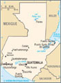 Guatemala
|
 Where to go in August
|

|
|
|
|
|
|
|
|
|
 |
|
|


 January

